These Simple Design Schemes Can Help Combat Climate Change for Coastal Cities
Rain gardens, little watercourses with water burbling over gravel fringed with a variety of water-loving plants, are becoming a more common sight along sidewalks across America. Amid the asphalt square miles of cities, these mini islands of engineered nature—technically bioswales—are among several natural-system solutions that work hard to manage stormwater runoff.
That task may seem prosaic but they are changing city dwellers’ relationship to water. After all, water is more insistently a presence in peoples’ lives as rising seas invade shoreline communities and torrential rains grow fiercer and more frequent, with storm sewers sometimes erupting out of manhole covers in turbid fountains.
Yes, we can rip out the storm drains and put in bigger pipes. We can build high walls along coastlines—if only we could afford to do these things. Nature is coming to the rescue: “Green infrastructure,” that is, engineered by hydrologists, plant biologists, ichthyologists, and landscape architects. As these experts inject nature into streets, parks, and beaches, our awareness of water’s impact on our senses and bodies grows. It’s almost been hard not to become an aficionado of these jolts of natural beauty—flowers, butterflies, the breeze-riffled surface of a pond—amid the freeway and parking lot urbanism people have built.
If one were to walk recently along the edge of Seattle’s Elliott Bay, they’d see construction crews planting new esplanades with strips of native trees and plants laced with trails and bioswales—momentary natural solitude steps from skyscrapers. It’s part of the Waterfront Seattle park, designed by James Corner, founder of the landscape architecture Field Operations. Returning sites to “predevelopment conditions” (in the new parlance), even ones where nature was obliterated 170 years ago, is part of the climate adaptation playbook.
Between a pair of wharves, the firm placed tousled mounds of gravel to form a pebbly cove. The beach is already strewn with driftwood. It has sprouted native plantings and welcomes gulls. Beneath the waves the bay bottom has been contoured to offer sustenance and hiding places for migrating juvenile salmon.
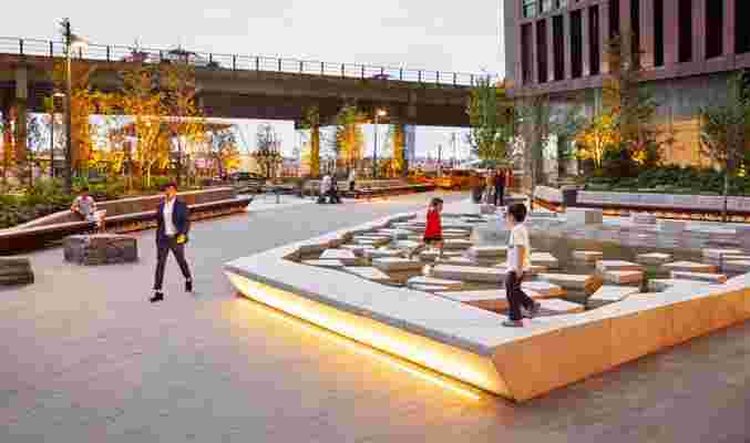
The First Avenue Water Plaza in New York City, designed by landscape architect SCAPE.
Across the country, at the base of a pair of Manhattan skyscrapers, delighted children skip across a fountain of stone-like slabs scattered at random atop a sheet of water. And while this is an idyllic scene, it’s meant to help the city become more eco-friendly. The First Avenue Water Plaza, designed by landscape architect SCAPE, surrounds this water feature with appealing beds of shrubs that are actually high-capacity bioswales designed to manage rooftop and site stormwater runoff. They are augmented by an underground pipe system that stores water diverted from increasing incursions by the nearby East River.
While the water feature outside of this pair of Manhattan skyscrapers is an appealing public amenity, the verdant planting beds absorb stormwater that might otherwise overwhelm the drainage system.
Most “grey” infrastructure—the street drains and underground pipes—“was designed for five- or ten-year storm events,” explained Walter Meyer, principal of the Local Office Landscape and Urban Design in New York. “We are soon going to default to nature-based natural infrastructure, because we are seeing repeated 500-year events, and only networked green infrastructure can handle it.”
Thus a skate park doubles as a water-detaining canal in Babalder Park, in Roskilde, Denmark, by architect Nordarch, Søren Nordal Enevoldsen. Rotterdam’s Water Square, designed by De Urbanisten, replaced a bleak public space with a terraced sunken plaza that features an inviting waterfall and varied drainage-detaining levels.
The sheer magnitude of violent weather spurs cities to start linking these installations together. In the redevelopment of a Seattle public housing tract for mixed-income housing called High Point, bioswales lining the streets pour their gathered runoff into a stream that tumbles down a slope ricocheting off plantings and boulders. The stream fills a “stormwater pond” lined with water-loving plants and visited by residents and herons alike. At each of these stages plants slow the flow of rainwater, absorb pollutants, and let soil drift to the bottom. In chaining its water-management elements together, Mithun, the architect, delivers clean water from the development into the nearby creek.
In dense, space-constrained areas there would seem to be little room for nature-based measures. Trees, says Walter Meyer, usher in “a new era of porosity in the city.” Street trees can draw a lot of water out of saturated soils, and Meyer is working with the flood-prone city of Miami on supercharging that performance in a prototype shared street where low-speed cars and pedestrians weave their way through a tree canopy. The asphalt is porous, supplying the roots with water and encouraging them to intertwine. Meyer says these “living streets” can draw very large quantities of excess groundwater up through the trees and into the air in a process called evapotranspiration. “You want the tree roots to touch each other, hold each other up, and interact,” he said. “In this way they will handle more water than the primeval forest that preceded it.”
In New Orleans, Hurricane Ida reminded residents that $14 billion worth of levees surrounding the city are not enough to stop local flooding after rainstorms. The Mirabeau Water Garden, which is ready to break ground in the city’s Gentilly neighborhood, is a 25-acre park contoured to infiltrate ordinary rainfall and hold floodwaters draining from the surrounding neighborhood. The park has swooping terraces that store and clean water, and it is also the home of species that thrive in different depths of inundation.
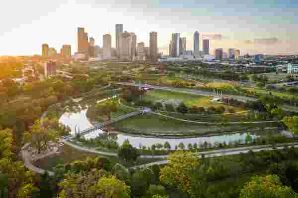
An aerial view of Buffalo Bayou Park near downtown Houston, Texas.
It is a downpayment on a much grander vision. Local architects Waggonner and Ball, inspired by the Dutch (the world’s water-management wizards), designed it as a component in the Greater New Orleans Water Plan, which would replace massive, blighting concrete-lined drainage canals with meandering waterways lushly planted at the edges. They could manage far more water while increasing natural areas accessible to residents and spurring investment. New Orleans could become its true self—a water city.
There’s still skepticism that plants and ponds can outperform grey infrastructure that has worked for decades. However, green infrastructure is not new. Since 1991, the city of New York has restored some 20 buried and degraded small watersheds—called Bluebelts—on Staten Island. The city’s Department of Environmental Protection has opened piped streams to daylight and connected them to marshes and ponds that meander among subdivisions and under bridged streets, preventing flooding and enhancing habitat. There was a learning curve, said Dana Gumb, who recently retired after working on Bluebelts since their inception. “Consultants developed hydrologic models to control stream velocity so they wouldn’t erode the banks. We calibrated the size of ponds to avoid overwhelming downstream stretches.”
When Hurricane Harvey came to a halt over the Houston metro area, dropping an extraordinary 50 inches of rain, the ordinarily peaceful stream running through Buffalo Bayou Park turned into a torrent that inundated the park and surrounding blocks. It sluiced soils from the bayou’s banks but the beloved park, opened 2015 to a design by the landscape architect SWA, remained largely intact.
The resiliency of the park and the shocking extent of the damage spurred Houston to push ahead with a century-old dream of turning its 150-mile network of bayous into a multi-use greenway augmented with flood-managing landscapes. SWA turned a golf course into a 178-acre Exploration Green, for example, a park wrapped around a floodwater-retaining lake that threads itself along the former greens. “Houston celebrates its diversity,” said SWA principal Scott McCready, “and it’s on display in the popularity of the greenways with every socio-economic group.”
Houston, like New Orleans, is especially susceptible to flooding, and it is re-drawing its flood maps to recognize vulnerabilities and requiring property owners to manage their own stormwater runoff—which will mean more porous surfaces and backyard bioswales. So are lots of other cities. “It takes a shock to get cities to adapt their thinking,” McCready said. “Of course, ideas that seemed radical 10 or 15 years ago now are mainstream.”